Arctic Cloud Detection and Sea Ice Characterization
One of my current projects is about improving surface characterization in the Arctic using passive shortwave satellite and airborne imagery. Although we have long studied the Arctic with satellites, sea ice poses a uniquely challenging problem. First, in order to get to the sea ice surface, we need to detect clouds over these bright surfaces which in itself is difficult due to limited contrast in both the visible and thermal parts of the spectrum. Second, the drifting nature of sea ice also presents a challenge to obtaining a temporal characterization.
My research in the Arctic aims to solve these issues and bridge the gaps in our understanding of Arctic sea ice evolution by:
- Developing a cloud detection algorithm specifically tailored for the Arctic using “high-resolution” passive imagers – MODIS and VIIRS.
- Tracking sea ice floes and retrieving their surface characteristics to build a spatio-temporal evolution dataset.
I am leveraging machine learning (and deep learning) algorithms for both these tasks to improve our current methods.

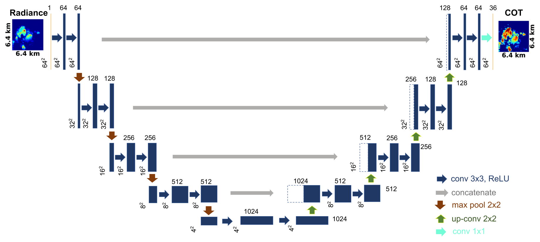
Cloud Optical Thickness Retrieval Using a Convolutional Neural Network (CNN)
We developed a new machine learning approach to retrieve cloud optical thickness (COT) fields from visible passive imagery. In contrast to the heritage independent pixel approximation (IPA), our convolutional neural network (CNN) retrieval takes the spatial context of a pixel into account and thereby reduces artifacts arising from net horizontal photon transfer, which is commonly known as independent pixel (IP) bias. The CNN maps radiance fields acquired by imaging radiometers at a single wavelength channel to COT fields. It is trained with a low-complexity (and therefore fast) U-Net architecture with which the mapping is implemented as a segmentation problem with 36 COT classes. The CNN was trained on a single radiance channel (600 nm) generated from a 3D radiative transfer model using large eddy simulations (LES) from the Sulu Sea. We examined the CNN model under various conditions based on different permutations of cloud aspect ratio and morphology, and we used appropriate cloud morphology metrics to measure the performance of the retrievals. Results indicate that the CNN is broadly successful in overcoming the IP bias and outperforms IPA retrievals across all morphologies. This work is intended to be used as a baseline for future implementations of the CNN that can enable generalization to different regions, scales, wavelengths, and sun-sensor geometries with limited training.
Links: Publication, Github
Radiative Transfer and Remote Sensing Tool Development
This project is led by Dr. Hong Chen (LASP).
We introduce the Education and Research 3D Radiative Transfer Toolbox (EaR3T) for quantifying and mitigating artifacts in atmospheric radiation science algorithms due to spatially inhomogeneous clouds and surfaces and show the benefits of automated, realistic radiance and irradiance generation along extended satellite orbits, flight tracks from entire aircraft field missions, and synthetic data generation from model data. EaR3T is a modularized Python package that provides high-level interfaces to automate the process of 3D radiative transfer (3D-RT) calculations as well as remote sensing tools.
Links: Publication, Github, Read the Docs
Other Projects
To view all my other projects, please visit my Github.
